Understanding Point Cloud Data: Transforming Industries with Precision and
In recent years, point cloud technology has emerged as a game-changer across various industries, including architecture, engineering, construction, and even manufacturing. This innovative method of capturing and representing three-dimensional data provides unparalleled accuracy and detail, paving the way for more efficient workflows and improved project outcomes. In this blog, we’ll explore what point cloud data is, how it works, and its numerous applications across different sectors.
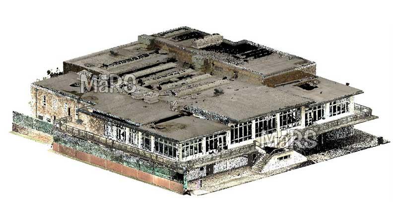
What is Point Cloud Data?
Point cloud data is a collection of data points defined in a three-dimensional coordinate system, representing the external surfaces of physical objects or environments. It is typically generated using laser scanning technology, where thousands or millions of data points are captured in a single scan. Each point in the cloud contains spatial coordinates (X, Y, Z), and together they create a detailed digital representation of the scanned environment.
The use of point cloud data allows for a comprehensive visualization of complex structures, capturing intricate details that traditional surveying methods may overlook. This level of precision is essential for industries that require exact measurements and thorough documentation.
How Point Cloud Data Works
The process of generating point cloud data involves several key steps:
Data Acquisition: Laser scanners are deployed in the field to capture the physical environment. These scanners emit laser beams that bounce back upon hitting surfaces, recording the time it takes for the light to return. This information is used to calculate the distance to each surface, resulting in a dense cloud of points.
Data Processing: After acquisition, the raw point cloud data is processed using specialized software to clean, filter, and organize the data. This step is crucial for enhancing the quality of the point cloud and ensuring its accuracy.
Model Creation: Once the data is refined, it can be used to create various models, such as 3D visualizations, Building Information Models (BIM), or CAD drawings. This conversion allows professionals to analyze the data and utilize it for design and planning purposes.
Applications of Point Cloud Data
Point cloud technology has a wide range of applications across multiple sectors:
Architecture and Construction: In architecture and construction, point cloud data is invaluable for creating accurate as-built models. It helps architects and engineers visualize existing conditions, ensuring that new designs align with the physical space. This technology also facilitates renovation projects, providing precise measurements and reducing the likelihood of errors.
Surveying and Mapping: Surveyors utilize point cloud data for topographic mapping and land surveying. The high level of detail captured by laser scanners allows for more accurate representations of land features, aiding in planning and development.
Manufacturing and Industrial Applications: In manufacturing, point cloud data is used for quality control and inspection. By comparing as-built components with their digital models, manufacturers can identify discrepancies and ensure that products meet specifications.
Cultural Heritage Preservation: Point cloud technology is also used in the preservation of cultural heritage sites. By creating detailed 3D models of historical buildings and artifacts, conservators can monitor changes over time and plan restoration efforts.
Virtual Reality and Gaming: Point clouds are increasingly used in virtual reality (VR) and gaming applications, allowing developers to create realistic environments by capturing real-world locations and translating them into digital spaces.
Benefits of Point Cloud Data
The advantages of using point cloud data are numerous:
High Precision: Point cloud data provides a level of accuracy that traditional surveying methods cannot match. This precision is critical for minimizing errors and ensuring successful project outcomes.
Time Efficiency: The ability to quickly capture vast amounts of data reduces the time required for surveying and documentation. This efficiency allows teams to focus on analysis and design rather than manual measurements.
Improved Collaboration: Point cloud data facilitates collaboration among stakeholders. With a shared digital representation of the environment, all parties can contribute their expertise, leading to more integrated and effective designs.
Enhanced Visualization: The 3D nature of point cloud data allows for better visualization of complex structures and environments. This clarity aids in communication and decision-making among project teams.
Conclusion
Point cloud technology is revolutionizing how industries approach data capture, analysis, and modeling. Its ability to provide high-precision, detailed representations of physical environments enhances workflows and improves project outcomes across various sectors. As technology continues to advance, the applications of point cloud data will only expand, offering even more innovative solutions to the challenges faced by professionals today.
At Scan to BIM Solutions, we are committed to harnessing the power of point cloud data to deliver exceptional Scan to BIM services. Whether you’re involved in construction, manufacturing, or cultural heritage preservation, point cloud technology can provide the accuracy and efficiency you need to succeed. Contact us today to learn how we can help transform your projects with our expertise in point cloud data!


Comments