U.S. Geospatial Imagery Analytics Market Growth, Overview with Detailed Analysis
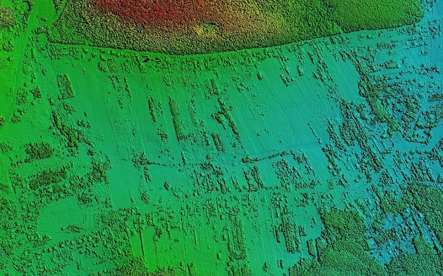
Geospatial imagery analytics is transforming various sectors in the U.S. by providing high-resolution satellite and aerial images that enable detailed spatial analysis. This technology is pivotal in sectors like agriculture, forestry, mining, defense and security, urban planning, and environmental monitoring. The U.S. market for geospatial imagery analytics is thriving due to advancements in technology, increased government funding, and the growing demand for real-time data analysis.
According to BIS Research, The U.S. geospatial imagery analytics market is estimated to reach $8.38 billion in 2033 from $6.04 billion in 2022, at a growth rate of 3.19% during the forecast period 2023-2033. This growth is driven by the increasing adoption of geospatial technologies across various industries, the need for efficient land and resource management, and the rising importance of spatial data in decision-making processes.
Construction and Infrastructure Development in Application Section to Dominate the U.S. Geospatial Imagery Analytics Market
The construction and infrastructure development segment of the U.S. geospatial imagery analytics market was valued at $0.88 billion in 2022 and is projected to reach $1.34 billion by 2033, with a compound annual growth rate (CAGR) of 4.07%. The rapid advancement of the Building Information Modeling (BIM) industry has significantly influenced both construction and design sectors. The integration of BIM and GIS introduces a new perspective on construction and planning, transitioning from 2D to 3D and enhancing digital building information modeling. Moreover, GIS data is essential for planning various infrastructure projects, including roads, railways, and airports.
Analytics in Product Section to Dominate the U.S. Geospatial Imagery Analytics Market by Solution
The U.S. geospatial imagery analytics market is projected to be led by the analytics segment in 2023, having generated $2.57 billion in revenue in 2022, and is anticipated to grow to $3.57 billion by 2033. In this market, companies like Orbital Insight provide AI-driven software platforms capable of performing analytics using various geospatial data sources, such as satellite and aerial imagery, location data, and automatic identification system (AIS) data. Similarly, EOS Data Analytics, a provider of cloud-based solutions, offers the EOSDA platform for applications including crop monitoring, land observation, and forest monitoring. This platform utilizes deep learning algorithms to analyze satellite imagery and deliver actionable insights.
Request A Detailed Sample in U.S. Geospatial Imagery Analytics Market!
Technological Advancements
Technological advancements are a key driver of growth in the geospatial imagery analytics market. Innovations such as artificial intelligence (AI) and machine learning (ML) are enhancing the capabilities of geospatial analysis. AI and ML algorithms can process vast amounts of spatial data quickly and accurately, providing deeper insights and predictive analytics. Additionally, the integration of geospatial data with Geographic Information Systems (GIS) and the development of cloud-based geospatial platforms are making these technologies more accessible and user-friendly.
Challenges and Opportunities
Despite its rapid growth, the geospatial imagery analytics market faces several challenges. Data privacy concerns, high costs of satellite imagery, and the need for specialized skills to analyze geospatial data are some of the barriers to market expansion. However, these challenges also present opportunities for innovation. The development of cost-effective imaging solutions, advancements in data security, and the creation of user-friendly analytics platforms are areas with significant growth potential.
Some Key Player in U.S. Geospatial Imagery Analytics Market:
Albedo Space Corp.
AllSource Analysis
AiDash
BENTLEY SYSTEMS, INCORPORATED
BlackSky Technology Inc.
Capella Space
VETRO FiberMap
VORTICS IMAGING
Weather Stream Inc.
Zonda
Download The Full TOC: Click Here!
Conclusion
The U.S. geospatial imagery analytics market is on a robust growth trajectory, driven by technological advancements and increasing demand across various sectors. As the technology continues to evolve, it will unlock new opportunities and applications, further cementing its role as a critical tool for spatial analysis and decision-making. The future of geospatial imagery analytics looks promising, with continued innovation and adoption poised to transform industries and improve efficiencies across the board.






Comments